
Commons:Graphic Lab/Map workshop
| Illustration Workshop | Map Workshop | Photography Workshop | Video and Sound Workshop |
 Map workshop
This workshop is part of the Graphics Lab, a project aimed at picture retouching to improve the graphical content of the Wikimedia projects. More information about the lab can be found on its main page and requests pages (Illustrations ; Photographs ; Maps ; Video and Sound). To ask questions or make a suggestions, see the talk page of the graphic lab page.
This specific page is the requests page for the Map Workshop. Anyone can make a request for a map to be created or improved. The standard format for making a request is shown below, along with general advice, and should be followed.
Make a request
Use the following template when making a new request, replacing the examples with your image(s) and request(s):
<gallery>
 IMAGENAME.EXT|Description of image
 IMAGE#TWO.EXT|2nd image (If there is one)
 ETCETCETC.EXT|Don't request too many at once, though
</gallery>

;Request:
: Details of your request go here… --~~~~
;Graphist opinion(s):
See also
[edit]| SpBot archives all sections tagged with {{Section resolved|1=~~~~}} after 7 days and sections whose most recent comment is older than 185 days. For the archive overview, see /Archive. The latest archive is located at /Archive/2025. | |
Russia Map Border
[edit]-
 Moscow boundaries need to be updated, they are outdated.

Article(s): Jewish Autonomous Oblast
- Request
- Moscow's boundaries need to be updated, they are outdated. --– Illegitimate Barrister (talk • contribs), 21:37, 4 August 2024 (UTC)
- Graphist opinion(s)
- Given this is likely an issue across all theoretically current Russian administrative border maps, it might be best to create a category to put maps needing an update in. CMD (talk) 13:59, 9 December 2024 (UTC)
Iraq Kurdistan political map
[edit]Article(s): Iraqi Kurdistan
- Request
- (Can anyone create a version of this map? Taken from this article. Ideally, we would have an English, Arabic and Kurdish version also. --الدبوني (talk) 07:17, 26 November 2024 (UTC)
- Graphist opinion(s)
- الدبوني: We have File:Kurdistan governorates 2015.png/File:Kurdistan governorates 2015-ar.png. Those will probably work well with appropriate captions. (The border of the east two governates is different but that doesn't affect the use at hand.) CMD (talk) 09:36, 29 November 2024 (UTC)
- @الدبوني and Chipmunkdavis: Hi,
- Displaying the map, if you click on Datawrapper under the map, you get a new display. Then this new map is composed thanks to an embedded svg. Copying/pasting this code will directly give a svg file (with probably some workaround).
- Copyright from OpenStreetMap contributors give a license compatible with uploading to Commons (to be confirmed).
- Yours, En rouge (talk) 14:09, 30 November 2024 (UTC)
- @الدبوني: Hi,
- Don't you think it will be better to start your page before any graphist works on your editing request?
- En rouge (talk) 15:15, 30 November 2024 (UTC)
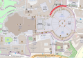
Correct Green Valley, IL map to put circular emphasis on right municipality
[edit]-
 Highlighting is on wrong village

Article(s): en:Green Valley, Illinois
- Request
- The red circle is on the wrong village. It needs to be moved over to where Green Valley actually is (towards the bottom left). Thanks! --WhisperToMe (talk) 18:55, 1 December 2024 (UTC)
- Graphist opinion(s)
- WhisperToMe The 02:49, 28 October 2017 version seems to have the circle in the right place, but there is a square that changes color. Which square color is correct? CMD (talk) 00:24, 2 December 2024 (UTC)
- @Chipmunkdavis: The red settlement (the others are gray) is the correct location. The map is supposed to depict Green Valley, seen here. Compare with Tazewell County here. The circle is instead over Armington (which is depicted here: File:Tazewell_County_Illinois_Incorporated_and_Unincorporated_areas_Armington_Highlighted.svg). The circle is supposed to emphasize Green Valley. WhisperToMe (talk) 01:05, 2 December 2024 (UTC)
- That does seem to suggest the 02:49, 28 October 2017 has the correct circle, but do you know what to do with the square? ie. can this be reverted, or does a new version have to combine the old circle and new square? CMD (talk) 01:08, 2 December 2024 (UTC)
- @Chipmunkdavis: I see. The square should be en:Heritage Lake, Illinois (a census-designated place) based on the placement. I'm not really sure why it is not filled in with gray. I checked File:Harris County Texas incorporated and unincorporated areas Cloverleaf highlighted.svg and I notice some census-designated places are filled in with grey but some are not. Maybe I should ping the uploader and ask them if CDPs are supposed to be gray or white. WhisperToMe (talk) 01:59, 2 December 2024 (UTC)
- If it is, just revert to 02:49, 28 October 2017. If not, should be easy enough to combine the two.
- CMD (talk) 02:09, 2 December 2024 (UTC)
- @Chipmunkdavis: I see. The square should be en:Heritage Lake, Illinois (a census-designated place) based on the placement. I'm not really sure why it is not filled in with gray. I checked File:Harris County Texas incorporated and unincorporated areas Cloverleaf highlighted.svg and I notice some census-designated places are filled in with grey but some are not. Maybe I should ping the uploader and ask them if CDPs are supposed to be gray or white. WhisperToMe (talk) 01:59, 2 December 2024 (UTC)
- That does seem to suggest the 02:49, 28 October 2017 has the correct circle, but do you know what to do with the square? ie. can this be reverted, or does a new version have to combine the old circle and new square? CMD (talk) 01:08, 2 December 2024 (UTC)
- @Chipmunkdavis: The red settlement (the others are gray) is the correct location. The map is supposed to depict Green Valley, seen here. Compare with Tazewell County here. The circle is instead over Armington (which is depicted here: File:Tazewell_County_Illinois_Incorporated_and_Unincorporated_areas_Armington_Highlighted.svg). The circle is supposed to emphasize Green Valley. WhisperToMe (talk) 01:05, 2 December 2024 (UTC)
French Indochina administrative divisions in 1937
[edit]-
 English version
 -
 French version


Article(s): [[]]
- Request
- I would like to have some changes on the máp:
- Some provinces seem to be missing from the map, such as Hà Nam province (shows as part of Nam Định province) and Phúc Yên province (shows as part of Vĩnh Yên province)
- I think that military teritories are also provinces, so they can named with their own names rather than just numbered territories (display within each other or just one type, 1e = Hải Ninh, 2e = Cao Bằng, 3e = Hà Giang, 4e = Lai Châu, 5e = Phongsaly)
- For English version, I think some provinces in Annam, Laos, a province in Tonkin (Pho Tuo = Phú Thọ), a province in Cambodia (typo I think: Svai Rieng = Svay Rieng) should be called with Vietnamese/Lao names rather than how the French at that time call it (Vinh = Nghệ An, Đồng Hới = Quảng Bình, Huế = Thừa Thiên, Tourane = Quảng Nam, Qui Nhơn = Bình Định, Sông Cầu = Phú Yên, Nha Trang = Khánh Hòa, Phan Rang = Ninh Thuận, Phan Thiết = Bình Thuận, Buôn Ma Thuột = Đắk Lắk, Đà Lạt = Đồng Nai Thượng (Đà Lạt has its own province-level special administrative region which can be shown in this map) and some provinces of Laos: Haut-Mekong = Houa Khong, Trấn Ninh = Houaphanh, Cammon = Khammuane, Bassac = Champasack/Champasak). It's optional in French version due to differences between how the French governors named it back then and how the French speaker call it now (if the French version is also need to change, Đồng Nai Thượng = Haut-Đồng Nai)
- Border between Thanh Hóa province and Nghệ An province (shows as Vinh) with Laos seems not right due to that border kept until now but looks different from the current one, so I need Thanh Hóa to have a small land point into Laos and west Nghệ An looks sharper, thanks! --Khanh ( talk | contribs | CA | vi ) 13:19, 10 December 2024 (UTC)
- Graphist opinion(s)
-
 Locations of major volcanic events in the Little Ice Age: 1641 to 1642 (red), 1667 to 1694 (blue), 1809 to 1831 (yellow), and other (green)

Article(s): en:Little Ice Age volcanism, es:Vulcanismo durante la Pequeña Edad de Hielo
- Request
- Please add a yellow dot corresponding to en:Zavaritski Caldera; a paper was just published proving it erupted in 1831. Map was made in 2020 by Marcolam308, who no longer seems to be active.
- Am, of course, open to solutions that rely less on static images like this PNG and more on dynamic maps or something. --Rotideypoc41352 (talk) 05:05, 7 January 2025 (UTC)
- Graphist opinion(s)
Christian Majority Countries
[edit]-
 Countries with absolute Christian majority (50%+)
 -
 same
same


Article(s): multiple articles, multiple wikis (already existing image, already used)
- Request
- Please update. See File talk:Christian Majority Countries.PNG#Outdated. I'm not so good with computer graphics. Tgeorgescu (talk) 20:40, 8 January 2025 (UTC)
- The same updates also need to be made in the Arabic version map File:Christian Majority Countries-ar.png. Orattas (talk) 10:58, 30 January 2025 (UTC)
- Tgeorgescu, could you provide a precise list of changes needed rather than examples? CMD (talk) 15:32, 30 January 2025 (UTC)
- @Chipmunkdavis: That would require a lot of work, and some of it may be questioned. So, I don't think I'm the proper person to do that. If you want a quick fix: just check the external map I have quoted there and check whether the percentage is above or below 50%. Tgeorgescu (talk) 16:01, 30 January 2025 (UTC)
Update for the Ankara–Sivas high speed railway line
[edit]-
 Map in German
 -
 Map in German and English
 -
 Map in Turkish
 -
 SVG version
 -
 PNG version


Article(s): Many articles across Wikipedia.
- Request
- In File:Rail transport map of Turkey.png (German), File:Rail transport map of Turkey-m.png (German and English) and File:Rail transport map of Turkey in Turkish.png (Turkish), the high speed railway line between Ankara and Sivas needs to be colored in red, and the same line in File:TCDD.svg and its duplicate File:Tcdd network.png (also the Istanbul–Eskisehir section) needs to be colored in dark blue. The en:Ankara–Sivas high-speed railway opened on April 26, 2023. These maps, which were regularly updated for new extensions, have not been updated for this latest extension.
- Graphist opinion(s)
Correct worldwide heron range
[edit]-
 Purported worldwide distribution of herons.
 -
 Grey herons exist where the first map does not show them (Sweden and Norway).


- Request
- The worldwide heron range is incorrect. The mistake I found is that it claims there are no herons in Norway and Sweden. This is wrong, I've seen grey herons there myself. Maybe there are other errors too. Ribidag (talk) 20:36, 3 February 2025 (UTC)
- Ok, it seems like I messed up with the title bit :( Ribidag (talk) 20:40, 3 February 2025 (UTC)
- Graphist opinion(s)
Public transport map for Oporto, Portugal
[edit]-
 Porto Subway routes diagram
 -
 Porto Suburban Trains map


Article(s): pt:Metro_do_Porto, pt:Metropolitanos de Portugal, pt:CP Urbanos do Porto, pt:CP Urbanos, pt:Transportes em Portugal, pt:Área Metropolitana do Porto, pt:Porto and the respective translations in other languages
- Request
- Oporto never had a map or routes diagram that unifies the two major public transport networks that serve the metropolitan area: it's Metro and Suburban Trains, not even on specialized websites such as Urban Rail, which mentions briefly the suburban railway but doesn't show it's extension or stops. It'd be very nice to have a map that unifies those networks, to be used in several Wikipedia articles, in Portuguese and other languages.
- It'd be a similar (though slightly less complex) work done on Public transport map of Rio de Janeiro. An official version of those two maps on the gallery (not on a free license, but for inspiration) are those two: Metro do Porto (subway) and the CP Urbanos do Porto (suburban train). Also, both the two free images above as well as the two official versions doesn't have recently constructed lines, and ideally would need to be corrected as well. --ArlindoPereira (talk) 09:21, 10 February 2025 (UTC)
- @ArlindoPereira Is it fine with you if I take this request, or do you want to wait for someone else, be honest, thanks. --please ping me-- Goran tek-en (talk) 13:53, 11 March 2025 (UTC)
- @Goran tek-en if you want to take I'd be honored, it'd be nice to work together with you again :) ArlindoPereira (talk) 15:47, 11 March 2025 (UTC)
- @ArlindoPereira Is it fine with you if I take this request, or do you want to wait for someone else, be honest, thanks. --please ping me-- Goran tek-en (talk) 13:53, 11 March 2025 (UTC)
- Graphist opinion(s)
 Request taken by --please ping me-- Goran tek-en (talk) 15:51, 11 March 2025 (UTC)
- @ArlindoPereira You can always ask me if you ever think I can create something you need.
- We will do the same kind of map, where the lines actually are in its right places? --please ping me-- Goran tek-en (talk) 16:00, 11 March 2025 (UTC)
- @ArlindoPereira Is this the overall area --please ping me-- Goran tek-en (talk) 16:15, 11 March 2025 (UTC)
- Yes, Braga on North, Aveiro on South, Marco de Canaveses on East, ocean on West. @Goran tek-enArlindoPereira (talk) 17:04, 11 March 2025 (UTC)
- @Goran tek-en whichever you think is easier, eventually both would be nice. I think geographical might be too stretched vertically, because Aveiro is too much to the south. ArlindoPereira (talk) 17:03, 11 March 2025 (UTC)
- @Goran tek-en if you want to get acquainted to the Porto network and start on a perhaps easier task (and at the same time check if doing a diagram instead of map would be feasible), you could start by updating the second image (Porto Suburban Trains Map) as a new line has been created as of last month. Their official (non-free) PDF map has been updated, it'd be nice to have a license-free version of it. ArlindoPereira (talk) 17:08, 11 March 2025 (UTC)
- @ArlindoPereira Is this the overall area --please ping me-- Goran tek-en (talk) 16:15, 11 March 2025 (UTC)
Porto Suburban Trains map/update
[edit]Extended content
|
|---|
@ArlindoPereira
|
- @Goran tek-en perfect, let's publish this one then and start the Metro one. As the network is on a small scale, it can be a bit closer (as in the basemap zoomed in a bit); eventually when we join the two, the CP map might need to be cutted a bit to fit (for instance between Nine to the north and Valadares to the south). ArlindoPereira (talk) 20:31, 7 April 2025 (UTC)
- @ArlindoPereira
- I will need the following;
- Name of the file
- Description (/language)
- Captions/s (/language)
- Category/ies at commons
- Structured data/Items portrayed in this file, the Q#, to be able to upload it at commons, thanks.
- --please ping me-- Goran tek-en (talk) 15:39, 8 April 2025 (UTC)
- Mapa dos Comboios Urbanos do Porto / Porto Urban Trains Map
- Mapa da região norte de Portugal mostrando as cinco linhas de comboios urbanos operados pela CP, e as integrações com demais linhas da CP e com o Metro do Porto. / Map of Portugal's north region showing the five urban train lines operated by CP and their integration with other CP lines and the Metro do Porto.
- (not sure how the description and the caption should be equal or different from each other)
- Category:CP Urbanos, Category:Comboios de Portugal, Category:Public transport maps
- Q2624115, Q10388221, Q10384270, Q25430027, Q124220670, Q18473945, Q124221046, Q2652989, Q86274083 --ArlindoPereira (talk) 12:28, 9 April 2025 (UTC)
- @ArlindoPereira
- / slashes or backslashes is not good in filenames, changed to _.
- Caption is intended to be a short oneliner description, computers and search engines from outside of wikimedia can read that field so stuff on commons can be found from the whole of internet.
- I had forgotten to add "place" map so I added and there for I show a new Draft porto train-12. Please replay to that, thanks.
- Could you also check the overall area for metro below.
- --please ping me-- Goran tek-en (talk) 11:20, 10 April 2025 (UTC)
- @Goran tek-en looks perfect, I think it is ready to be published. For the filename, I think you can choose either the Portuguese or the English one, not necessarily both. ArlindoPereira (talk) 11:49, 10 April 2025 (UTC)
- @ArlindoPereira
- Now you can find it here Porto Urban Trains Map.
- Please check all the information, also links for wikipedia, wikidata and structured data.
 Done --please ping me-- Goran tek-en (talk) 13:49, 10 April 2025 (UTC)
- @Goran tek-en super, all is correct, already added to articles in multiple languages. Thanks :) ArlindoPereira (talk) 14:16, 10 April 2025 (UTC)
- @Goran tek-en looks perfect, I think it is ready to be published. For the filename, I think you can choose either the Portuguese or the English one, not necessarily both. ArlindoPereira (talk) 11:49, 10 April 2025 (UTC)
- @ArlindoPereira
- @Goran tek-en perfect, let's publish this one then and start the Metro one. As the network is on a small scale, it can be a bit closer (as in the basemap zoomed in a bit); eventually when we join the two, the CP map might need to be cutted a bit to fit (for instance between Nine to the north and Valadares to the south). ArlindoPereira (talk) 20:31, 7 April 2025 (UTC)
Metro Porto
[edit]Is this the correct area for Metro?
- @Goran tek-en: It needs to go further north. The northest station is Póvoa de Varzim. The other limits are correct.--ArlindoPereira (talk) 12:03, 10 April 2025 (UTC)
- @ArlindoPereira Is not the line E supposed to go all the way to Estádio do Dragão, OSM. --please ping me-- Goran tek-en (talk) 16:10, 10 April 2025 (UTC)
- @Goran tek-en it was reduced, and later expanded to it again. Looks like OSM is outdated. ArlindoPereira (talk) 20:15, 10 April 2025 (UTC)
- @ArlindoPereira Is not the line E supposed to go all the way to Estádio do Dragão, OSM. --please ping me-- Goran tek-en (talk) 16:10, 10 April 2025 (UTC)
Update outdated map
[edit]-
 Outdated map

Article(s): en:Streetcars in New Orleans
- Request
- Hi, this map is outdated. Please update it. Thank you! --OrdinaryScarlett (talk) 09:49, 13 February 2025 (UTC)
- @OrdinaryScarlett As the requester it would be great if you provided a source for the update, so graphic worker knows what to change/add, thanks. --please ping me-- Goran tek-en (talk) 15:56, 13 February 2025 (UTC)
- @Goran tek-en: Ah, my apologies. The red Canal Streetcar Line to Cemeteries should be recolored red, the light green Canal Streetcar Line to City Park & Museum should be recolored red, the yellow Rampart–Loyola Streetcar Line should be recolored purple, and a new light blue line called the Loyola–Rampart Streetcar Line should be created running with the Rampart–Loyola Streetcar Line from Union Passenger Terminal to Rampart Street, then running with the Canal Streetcar Line from Rampart Street to Canal Street, where it turns and takes over the half of the dark blue Riverfront Streetcar Line from Canal Street to French Market. The dark blue Ricerfront Streetcar Line should be removed from the map, with the segment between John Churchill Chase Street and Canal Street being removed. OrdinaryScarlett (talk) 01:00, 14 February 2025 (UTC)
- @OrdinaryScarlett As the requester it would be great if you provided a source for the update, so graphic worker knows what to change/add, thanks. --please ping me-- Goran tek-en (talk) 15:56, 13 February 2025 (UTC)
- Graphist opinion(s)
Map used in around 80 articles (improvement/correction)
[edit]-
 Map of early historic south India
 -
 Periplous of the Erythraean Sea locations


Article(s): Around 80 articles
- Request
- 1. Map of early historic south India - kindly remove the internal borders from the map (as they are largely estimations - locations of various ancient polities or tribes). Please smudge the lines or something. 2. Periplous of the Erythraean Sea locations - This image looks incredibly amateur. Kindly remove the strange white fog all over the image. Please make this a professional map. --JamesMdp (talk) 14:58, 23 February 2025 (UTC)
- Graphist opinion(s)
Updating a map
[edit]-
 Turkey regions map for use on Wikivoyage, English version

Article(s): Turkey on Wikivoyage
- Request
- Hello. The map is clearly lacking some major roads. Could anybody kindly update it to 2025 status-quo? -Dudewithafez (talk) 21:56, 27 February 2025 (UTC)
- Graphist opinion(s)
Maps of the Principality of Monaco
[edit]- Request
- All maps of the Principality of Monaco should now feature the new Mareterra district, built on the sea and opened to the public in December 2024. --InfattiVedeteCheViDice (talk) 08:52, 23 January 2025 (UTC)
- Graphist opinion(s)
Ireland motorway maps
[edit]-
 Original image
 -
.png/93px-Major_roads_in_Ireland_(update_of_2018).png) Modification of original image, updated in 2018 but still with mistakes
Modification of original image, updated in 2018 but still with mistakes

.png)
Article(s): en:Motorways in the Republic of Ireland, en:History of roads in Ireland, various other Irish motorway articles
- Request
- I'd like to make a request for SVG versions of Irish motorway maps if they can be made. It might be a lot of work, especially if you're unfamiliar with the Irish road network ‒ for that reason, I have given the following information to make my request as clear as possible, going by the first image:
- The map features national primary roads (which include motorways) only.
- It requires updates for extended or newly constructed motorways. These are the extension of the M18, the construction of the M17 and the extension of the M11.
- It is missing route numbers for the M50, the M2, the N19 (near Limerick), the N23 (near Tralee), the N28 (near Cork) and the N29 (near Waterford).
- Apart from the N31 and small section of the N11, all national roads shown in Dublin (inside the M50) should be removed (these roads were downgraded in 2012).
- Apart from the N6, all national roads around Galway should be removed (these roads were downgraded after the construction of the M17 and M18).
- Google Maps or OpenStreetMap shows the current Irish road network. Route number shields can be found at Category:Diagrams of route signs of Ireland. A request was made in 2018 but was archived upon request assumably due to the user having made the map themselves (second image). Derivations of the map were made to highlight specific sections of motorway for their relevant articles, it would really be appreciated if those could be made too. Please let me know if you need more information! Thanks in advance. --EthanL13 | talk 14:52, 22 January 2025 (UTC)
- Graphist opinion(s)
![]() Request taken by --please ping me-- Goran tek-en (talk) 14:27, 30 March 2025 (UTC)
Request taken by --please ping me-- Goran tek-en (talk) 14:27, 30 March 2025 (UTC)
Just as you say I have no knowledge of this so I will need your support during this, thanks. --please ping me-- Goran tek-en (talk) 14:27, 30 March 2025 (UTC)
- @EthanL13 I don't really understand, you ask for SVG versions of Irish motorway maps but you link to national primary roads which includes national roads and you talk about different national roads to be included.
- Is it just motorways or not?
- --please ping me-- Goran tek-en (talk) 17:31, 31 March 2025 (UTC)
- @Goran tek-en Hi, apologies for the confusion. In Ireland, motorways are considered to be national primary roads. Thus, the map should include both motorways, M, and national roads, N (but not N51 and after), as the current PNGs do. EthanL13 | talk 18:06, 31 March 2025 (UTC)
- @EthanL13
- ----
- Those drafts are PNG versions of the original SVG file I'm working in and will upload to commons.
- Those drafts are shown for proofreading only.
- ----
- I couldn't find a sign for M12 so I created it File:M12-IE_confirmatory.svg, when it was added to this Category:Diagrams_of_motorway_number_signs_of_Ireland it ended up last. I can't find out how to get into edit view to fix this, maybe need someone with more permissions?
- Right now I need you to check if those motorways (not national primary roads) have the correct stretches for the different numbers. Don't think about layout stuff, will fix that later ones all the correct roads are in place.
- Draft ireland roads-1.
- --please ping me-- Goran tek-en (talk) 15:47, 4 April 2025 (UTC)
- @Goran tek-en Looks good! The only motorway I didn't see yet was the M20. Will there be a distinction in colour for motorways and national roads?
- I hadn't realised you would do the route numbers for Northern Ireland, where UK-design signs are used. Perhaps you might use those from Category:Generic British motorway plaques in that case (as well as Category:A-road signs of the United Kingdom). EthanL13 | talk 16:49, 4 April 2025 (UTC)
- @EthanL13
- To get some kind of harmony on the stuff created here, we try to stick to File:Maps template-en.svg as much as possible. So yes, there will be a difference between the different types of roads.
- Please remember all the time, I have zero knowledge of this. So if you want me to use different signs for different areas you have to explain in detail which should not be Irish and what to use, hope you understand.
- Context: At the same time as I work on this I do work on a map of Greater Lincolnshire, England and maps for public transportation in Portugal/Porto. So there is no way I can have knowledge on it all, thanks. --please ping me-- Goran tek-en (talk) 17:00, 4 April 2025 (UTC)
- @EthanL13 Can't find M20, please show on map or other way. --please ping me-- Goran tek-en (talk) 17:03, 4 April 2025 (UTC)
- I was just saying since the originals didn't have route shields for Northern Ireland. I do of course understand.
- The M20 motorway is located south of Limerick. EthanL13 | talk 17:12, 4 April 2025 (UTC)
- @EthanL13 Thanks, as we are creating a new map I do not look to much on the old ones as they are not correct, so it's easier for me to create from scratch with your knowledge. Just tell me what to add and remove in the drafts so the final result will be what you want. --please ping me-- Goran tek-en (talk) 17:20, 4 April 2025 (UTC)
- @EthanL13 So I understand, do you want roads in Northen Ireland but with different signs or no roads at all. --please ping me-- Goran tek-en (talk) 12:11, 6 April 2025 (UTC)
- @Goran tek-en Having thought about it, I think that the map should not show roads (and placenames) in Northern Ireland, since the purpose of the maps are to display roads in the Republic only.
- However, maybe a version of the map could be made for the roads in Ireland article, which shows the major roads (motorways and national primary roads in the Republic, motorways and A-roads in the North), but without route number signs.
- So, to avoid confusion and clarify my request:
- Map of major roads in the Republic of Ireland – don't display roads in Northern Ireland
- Republic of Ireland motorway maps – same as above, but highlights each section of motorway (as in Category:Maps of motorways in Ireland
- Map of major roads on the island of Ireland – display roads in both the Republic and the North, but no route shields
- Map of major roads in the Republic of Ireland – don't display roads in Northern Ireland
- EthanL13 | talk 12:46, 6 April 2025 (UTC)
- @EthanL13 So I understand, do you want roads in Northen Ireland but with different signs or no roads at all. --please ping me-- Goran tek-en (talk) 12:11, 6 April 2025 (UTC)
- @EthanL13 Thanks, as we are creating a new map I do not look to much on the old ones as they are not correct, so it's easier for me to create from scratch with your knowledge. Just tell me what to add and remove in the drafts so the final result will be what you want. --please ping me-- Goran tek-en (talk) 17:20, 4 April 2025 (UTC)
- @EthanL13
- @Goran tek-en Hi, apologies for the confusion. In Ireland, motorways are considered to be national primary roads. Thus, the map should include both motorways, M, and national roads, N (but not N51 and after), as the current PNGs do. EthanL13 | talk 18:06, 31 March 2025 (UTC)
Vectorize raster map files
[edit]-
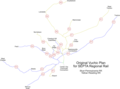 Raster map 1
 -
 Raster map 2
 -
 Raster map 3
 -
 Raster map 4
 -
 Raster map 5


Article(s): en:SEPTA Regional Rail, en:PATCO Speedline, en:Delaware River Basin Commission, and en:Delaware Valley Regional Planning Commission
- Request
- Hi! Please vectorize these three raster map files. Please add Franklin Square station to the third map since it will be reopening next month. Thank you! --OrdinaryScarlett (talk) 11:46, 3 March 2025 (UTC)
- Graphist opinion(s)
Update and vectorize biomes of Turkey
[edit]I used an online tool to crop


but I could not figure out how to save it as svg
Article(s): en:List of ecoregions in Turkey and others
- Request
- I looked in “Category:Biome maps” but I could not find anything. I would like to add the names of the biomes so they can be translated.
Could you possibly update per [1][2]? --Chidgk1 (talk) 11:12, 10 March 2025 (UTC)
- Graphist opinion(s)
Somalia Civil War update
[edit]-
 Current map used for the Somali Civil War page

Article(s): en:Somali Civil War
- Request
- SO Al-Shabab now controls the towns of en:Balad, Somalia 1 and en:Adale 2 Could a copy of this map be made (since it is specifically for 4 OCtober) that describes the current situation, please?--Genabab (talk) 00:22, 11 March 2025 (UTC)
- Graphist opinion(s)
Map is unmaintainable by editors who might wish to correct details
[edit].png)

Article(s): wikipedia:en:Law#Legal_systems
- Request
- Are there any frameworks or tools that could replace this file with a version that maintains the high graphical quality of the original, but permits granular editing (for example of facts like changing political boundaries, or developments in the subject matter, or corrections resulting from sourcing errors)? TheFeds 21:56, 12 March 2025 (UTC)
- Graphist opinion(s)
maps of the four voyages of Christopher Columbus
[edit]-
 This map has indications of cities that at the time of Columbus' voyage had not yet been founded.
 -
 This map has indications of cities that at the time of Columbus' voyage had not yet been founded.
 -
 This map has indications of cities that at the time of Columbus' voyage had not yet been founded.
 -
 This map has indications of cities that at the time of Columbus' voyage had not yet been founded.
 -
 This map has indications of cities that at the time of Columbus' voyage had not yet been founded.


Article(s): Christopher_Columbus and spanish version Cristóbal_Colón
- Request
- (This maps has indications of cities that at the time of Columbus' voyage had not yet been founded.) --Debray05 (talk) 16:02, 14 March 2025 (UTC)
- @Debray05
- Suggestions:
- You could put that information in the different maps Information part and write which, because maybe they are included so that people will easier locate the routes.
- If you want some cities removed you will have to provide which cities in which map so the graphic worker will know (probably the graphic worker will have no knowledge of this, this is your field of interest/knowledge) and then they can be uploaded as new versions and not overwrite the current ones.
- --please ping me-- Goran tek-en (talk) 14:05, 30 March 2025 (UTC)
- Graphist opinion(s)
Syria ethno-religious map
[edit]-
 Syria ethno-religious map

Article(s): Siria
- Request
- Could someone vectorize this map? It doesn’t need to be identical, but it should contain the same information (patterns). --Yeagvr (talk) 20:08, 22 March 2025 (UTC)
- Graphist opinion(s)
- Request taken by — Meghmollar2017 • Talk • 16:29, 6 April 2025 (UTC)
Discrepancy on Vatican City map
[edit]-
 Map (the one in question) used in the Vatican City infobox.
 -
 Map on the Geography of Vatican City page, showing the Ricciolo d'Italia just north of St. Peter's Square.
 -
 Map on the Ricciolo d'Italia article, highlighting the area in question.


- Article(s)
On the Vatican City page in the English Wikipedia. For other locations, see here. See also, for reference, the Wikimedia category Ricciolo d'Italia.
- Request
This request was also submitted on the English Wikipedia Graphics Lab/Illustration workshop page. The vector map used for Vatican City articles is missing a narrow part of Italian territory that curls along the northern edge of St. Peter's Square. Called the Ricciolo d'Italia, or "Curl of Italy," it can be seen in the Geography of Vatican City article's map, included above. The map on the Ricciolo d'Italia article itself, also included, highlights the area. It can be seen on the OpenStreetMap also, and the map on the Encyclopedia Britannica article for Vatican City shows it as well. Maybe someone can correct this discrepancy. Indefatigable2 (talk) 16:03, 25 March 2025 (UTC)
- Graphist opinion(s)
![]() Request taken by --please ping me-- Goran tek-en (talk) 13:34, 30 March 2025 (UTC)
Request taken by --please ping me-- Goran tek-en (talk) 13:34, 30 March 2025 (UTC)
- @Indefatigable2 I checked the file you link to above Vatican_City_map_EN and what I can see it's included in that.
- If you want other images edited please list them here, thanks. --please ping me-- Goran tek-en (talk) 13:56, 30 March 2025 (UTC)
- Yes, Goran tek-en, I know it's included in that map—I put it there for reference, as I attempted to explain. The file I'm asking to be edited, the "one in question," is the green/gray map on the left, which is used in the Vatican City infobox. As you can see, this map doesn't have the Ricciolo d'Italia north of St. Peter's Square. To make it clear, this is the file I'm asking to be edited. Thank you. Indefatigable2 (talk) 14:21, 30 March 2025 (UTC)
- @Indefatigable2 Like this Draft vatican-1. --please ping me-- Goran tek-en (talk) 14:58, 30 March 2025 (UTC)
- @Goran tek-en That's right, yes. Indefatigable2 (talk) 15:02, 30 March 2025 (UTC)
- @Goran tek-en And if you're going to upload the new version, I'd suggest mentioning "Ricciolo d'Italia" in the edit description/comment, for clarity. Thanks. Indefatigable2 (talk) 15:05, 30 March 2025 (UTC)
- @Indefatigable2 New version uploaded, Done, please close this. --please ping me-- Goran tek-en (talk) 15:25, 30 March 2025 (UTC)
- @Indefatigable2 New version uploaded,
- @Goran tek-en And if you're going to upload the new version, I'd suggest mentioning "Ricciolo d'Italia" in the edit description/comment, for clarity. Thanks. Indefatigable2 (talk) 15:05, 30 March 2025 (UTC)
- @Goran tek-en That's right, yes. Indefatigable2 (talk) 15:02, 30 March 2025 (UTC)
- @Indefatigable2 Like this Draft vatican-1. --please ping me-- Goran tek-en (talk) 14:58, 30 March 2025 (UTC)
- Yes, Goran tek-en, I know it's included in that map—I put it there for reference, as I attempted to explain. The file I'm asking to be edited, the "one in question," is the green/gray map on the left, which is used in the Vatican City infobox. As you can see, this map doesn't have the Ricciolo d'Italia north of St. Peter's Square. To make it clear, this is the file I'm asking to be edited. Thank you. Indefatigable2 (talk) 14:21, 30 March 2025 (UTC)
Nguyễn dynasty map
[edit]-
.svg/120px-Nguyen_Dynasty_(orthographic_projection).svg.png) Orthographic map of Nguyễn dynasty
Orthographic map of Nguyễn dynasty -
.png/120px-Maps_of_Vietnam_during_the_reign_of_Emperor_Minh_Mạng_(1820-1841).png) Maps of Vietnam during the reign of Emperor Minh Mạng
Maps of Vietnam during the reign of Emperor Minh Mạng
.svg)
.png)
Article(s): Nguyễn dynasty, Dynastie Nguyễn
- Request
- I would like to have some corrections for the map:
- The land mentioned as Sip Song Chau Tai should be gray/white because not only because the Lê dynasty lost that land to China but rhe Sip Song Chau Thai itself was a tusi, not a tributary state
- These territory: 1, 2 should be dark green/red because it was land of native tribes submitted to the dynasty, not parts of J'rai chiefdoms
- The drainage basin of Sé San in Kon Tum province (can be seen in this map) should be gray/white because it was kingdom of Champasak land, as said in Les jungles Moi by Henri Maitre
- The provinces of Bolikhamsay, Savannakhet of Laos, Nakhon Phanom of Thailand should be dark green/red as said in Đại Nam nhất nhống chí by Embassy of National history.
- Mondulkiri should be light green/red because is was J'rai chiefdoms land. --Khanh ( talk | contribs | CA | vi ) 11:55, 30 March 2025 (UTC)
- Graphist opinion(s)
Artemis Accords members.png
[edit]-
 the png file

.jpg)
.jpg)
Article(s): en:Artemis Accords
- Request
- Can anyone please add Bangladesh to the list? Is there any reason for it being a PNG file instead of SVG? --— Meghmollar2017 • Talk • 17:18, 8 April 2025 (UTC)
- Graphist opinion(s)
- Done by @Yiosie2356 — Meghmollar2017 • Talk • 11:49, 9 April 2025 (UTC)
- ↑ Western Eurasia | Realm & Subrealms (in en). One Earth (2025-03-07). Retrieved on 2025-03-10.
- ↑ Central Eurasia | Realm & Subrealms (in en). One Earth (2025-03-07). Retrieved on 2025-03-10.